Geographical Location


w2.gif


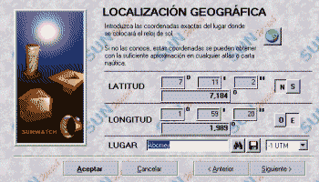
In this screen the geographic coordinates of the clock location are input.

LATITUDE AND LONGITUDE

Latitude and Longitude are input in [degrees, minutes, seconds] or [decimal degrees] format.
To avoid the use of signs, standard compass directions are input (N,S,E,W).


LOCATION DATABASE

The program has a database with more than 2000 locations around the world. To look for a given city, quickly type the first letters of the name and the program will show its coordinates. If your city
is not listed, you can add it to the database.

ADDITION OF A NEW CITY

To add an unlisted city to the database for future use, use the following method:

1. Type the complete name of the new city  
2. Input its latitude and longitude  
3. Select the button botongu.gif, that will insert the new city in the database. Confirmation is requested for a new city.  
 
TIME CORRECTION utm.gif  
To simplify the correction for longitude and for daylight savings time, the program finds the number of hours that the time differs from the 0º meridian by counting the integral number of 15º time zones from the Greenwich prime meridian to the location. The remaining fractional part of the time difference depends on whether the sundial location is east (leads) or west (lags) of the center meridian of the locations time zone. For a location east of this central meridian solar time will be earlier (lead) than civil time; for a location west of the central meridian solar time will be later (lag) than civil time. The total correction for longitude and daylight savings time (if in effect) can be made using this method.